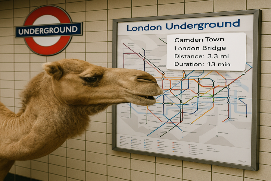
DISCLAIMER: Image is generated using FREE version of ChatGPT.
Map::Tube is one of my earliest creations. It was made public on 25th October 2010 to be precise.
I’ve given talks on the topic at various Perl conferences and even contributed an article to the Perl Advent Calendar 2024.
There’s also a 5-part blog series initiated by Pual Cochrane on the subject. You can check out part one and I highly recommend following the rest of the series as it gets published.
On Apr 15th, 2025, I received an email asking whether there were any plans to add metadata to stations links such as phyiscal distance or estimated tansit times. Honestly the idea never crossed my mind before.
That question has been on my mind ever since. I couldn’t stop thinking how this could be implemented without requiring too many changes or breaking existing maps.
My initial thought was how can metadata be allowed in the map file in the simplest way possible?
I was looking for a minimalist solution.
For those who are new to Map::Tube, here’s a sample map, from the cookbook:
    A <-> B <-> F <-> G <-> H
    A <-> C <-> F
    A <-> C <-> D <-> E <-> F
The same represented in a diagram as below:
             A(1)  -----  B(2)
             /               \
          C(3)   --------  F(6) --- G(7) ---- H(8)
             \               /
             D(4)  -----  E(5)
To keep it simple, we have used single line connecting all the stations.
The data file for the above map in XML format looks like below:
<?xml version="1.0" encoding="UTF-8"?>
<tube name="Sample">
    <lines>
       <line id="L1" name="L1" />
    </lines>
    <stations>
       <station id="L01" name="A" line="L1:1" link="L02,L03"         />
       <station id="L02" name="B" line="L1:2" link="L01,L06"         />
       <station id="L03" name="C" line="L1:3" link="L01,L04,L06"     />
       <station id="L04" name="D" line="L1:4" link="L03,L05"         />
       <station id="L05" name="E" line="L1:5" link="L04,L06"         />
       <station id="L06" name="F" line="L1:6" link="L02,L03,L05,L07" />
       <station id="L07" name="G" line="L1:7" link="L06,L08"         />
       <station id="L08" name="H" line="L1:8" link="L07"             />
    </stations>
</tube>
And the same in JSON format looks like below:
{
    "name"     : "Sample",
    "lines"    : { "line"    : [ { "id" : "L1", "name" : "L1" } ] },
    "stations" : { "station" : [ { "id" : "L01", "name": "A", "line": "L1:1", "link": "L02,L03"         },
                                 { "id" : "L02", "name": "B", "line": "L1:2", "link": "L01,L06"         },
                                 { "id" : "L03", "name": "C", "line": "L1:3", "link": "L01,L04,L06"     },
                                 { "id" : "L04", "name": "D", "line": "L1:4", "link": "L03,L05"         },
                                 { "id" : "L05", "name": "E", "line": "L1:5", "link": "L04,L06"         },
                                 { "id" : "L06", "name": "F", "line": "L1:6", "link": "L02,L03,L05,L07" },
                                 { "id" : "L07", "name": "G", "line": "L1:7", "link": "L06,L08"         },
                                 { "id" : "L08", "name": "H", "line": "L1:8", "link": "L07"             }
                               ]
                 }
}
Going back to the original question, how do I allow station metadata in the map file?
My first instinct was to include it in the "link" attribute of "station" element.
Since a station can be linked to one or more other stations, we could easily attach metadata related to each linked station.
The next question then becomes how do we add metadata for the distance and duration of each linked station?
For example, consider a station L01 that is linked to two stations L02 and L03:
{ "id" : "L01", "name": "A", "line": "L1:1", "link": "L02,L03" }
The linked stations of L01 now looks like below:
    Before: "link": "L02,L03"
    After : "link": "L02|D-1.5|T-30,L03|D-1.2|T-25"
The whole definition would now look like below:
{ "id" : "L01", "name": "A", "line": "L1:1", "link": "L02|D-1.5|T-30,L03|D-1.2|T-25" }
What does this mean?
It means the distance from station L01 to L02 is 1.5 km and the estimated time to reach it is 30 minutes.
I’m not too concerned about the unit for now.
To be honest, this approach looks a bit scary.
There’s a real possibility it could break existing maps.
Luckily, I have a rather large and very complicated London Tube Map that I can use to test any changes.
To avoid issues, I should make this change optional as not every map will include this kind of metadata.
So, I decided to take the sample map above as a base and convert it into this new structure shown below:
<?xml version="1.0" encoding="UTF-8"?>
<tube name="Sample">
    <lines>
       <line id="L1" name="L1" />
       <line id="L2" name="L2" />
    </lines>

    <attributes distance="km" duration="min" />

    <stations>
       <!-- Junctions -->
       <station id="J01" name="C" line="L1:3,L2:1" link="S01|D-1.7|T-15,S04|D-1.1|T-13,J02|D-2.5|T-30" />
       <station id="J02" name="F" line="L1:6,L2:2" link="S02|D-2.2|T-25,S05|D-2.1|T-23,S07|D-2.5|T-18,J01|D-1.5|T-30" />

       <!-- Line 1 -->
       <!-- Route 1: A <-> C <-> D <-> E <-> F <-> G <-> H -->
       <!-- Route 2: A <-> B <-> E <-> F <-> G <-> H -->
       <station id="S01" name="A" line="L1:1"      link="S02|D-1.5|T-10,J01|D-1.7|T-15" />
       <station id="S02" name="B" line="L1:2"      link="S01|D-1.5|T-10,J02|D-2.2|T-25" />
       <station id="S04" name="D" line="L1:4"      link="J01|D-1.1|T-8,S05|D-1.4|T-13"  />
       <station id="S05" name="E" line="L1:5"      link="S04|D-1.4|T-13,J02|D-2.1|T-23" />

       <!-- Line 2 -->
       <!-- Route 3: C <-> F <-> G <-> H -->
       <station id="S07" name="G" line="L1:7,L2:3" link="J02|D-2.5|T-28,S08|D-1.2|T-10" />
       <station id="S08" name="H" line="L1:8,L2:4" link="S07|D-1.2|T-10" />
    </stations>
</tube>
If you noticed, I have two lines, L1 and L2, in the above sample map.
Also we have added units in the map file like below:
<attributes distance="km" duration="min" />
To make it easy to read, I have grouped the stations.
In my experiment today, I am going to use the XML formatted data but in case you are looking for JSON formatted data for the sample map, I used this one-liner to convert the XML data into JSON format.
#!/usr/bin/env perl

use v5.38;
use XML::Twig;
use JSON::MaybeXS;

say JSON::MaybeXS->new
                 ->canonical(1)
                 ->utf8
                 ->pretty
                 ->encode(XML::Twig->new
                                   ->parsefile($ARGV[0])
                                   ->simplify(keyattr => 'stations', forcearray => 0));
This is the result, you end up with in the end:
{
   "attributes" : {
      "distance" : "km",
      "duration" : "min"
   },
   "lines" : {
      "line" : [
         {
            "id" : "L1",
            "name" : "L1"
         },
         {
            "id" : "L2",
            "name" : "L2"
         }
      ]
   },
   "name" : "Sample",
   "stations" : {
      "station" : [
         {
            "id" : "J01",
            "line" : "L1:3,L2:1",
            "link" : "S01|D-1.7|T-15,S04|D-1.1|T-13,J02|D-2.5|T-30",
            "name" : "C"
         },
         {
            "id" : "J02",
            "line" : "L1:6,L2:2",
            "link" : "S02|D-2.2|T-25,S05|D-2.1|T-23,S07|D-2.5|T-18,J01|D-1.5|T-30",
            "name" : "F"
         },
         {
            "id" : "S01",
            "line" : "L1:1",
            "link" : "S02|D-1.5|T-10,J01|D-1.7|T-15",
            "name" : "A"
         },
         {
            "id" : "S02",
            "line" : "L1:2",
            "link" : "S01|D-1.5|T-10,J02|D-2.2|T-25",
            "name" : "B"
         },
         {
            "id" : "S04",
            "line" : "L1:4",
            "link" : "J01|D-1.1|T-8,S05|D-1.4|T-13",
            "name" : "D"
         },
         {
            "id" : "S05",
            "line" : "L1:5",
            "link" : "S04|D-1.4|T-13,J02|D-2.1|T-23",
            "name" : "E"
         },
         {
            "id" : "S07",
            "line" : "L1:7,L2:3",
            "link" : "J02|D-2.5|T-28,S08|D-1.2|T-10",
            "name" : "G"
         },
         {
            "id" : "S08",
            "line" : "L1:8,L2:4",
            "link" : "S07|D-1.2|T-10",
            "name" : "H"
         }
      ]
   }
}
Since this is an experimental feature, I didn’t want to touch the master copy.
I could have created a branch and made the changes there but I decided against it.
Why? Because as of today, I’m not sure what the future holds for this experiment.
Instead, I chose to create a separate repository on GitHub purely for experimental purposes.
It’s based on Map::Tube v4.07.
Let’s get to the real work.
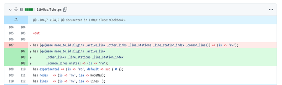
We’ve added a new optional attribute units to the Map::Tube package.
This attribute would capture the units for the distance and the duration, something like below:
{ distance => 'km', duration => 'min' }
Next, we have added an optional attribute attrs to the Map::Tube::Node package.
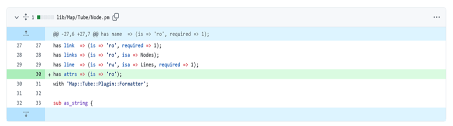
This new attribute would capture the following information for each station:
link="S02|D-1.5|T-10,J01|D-1.7|T-15"
into something like below:
       {
            distance => { 'S02' => 1.5, 'J01' => 1.7 },
            duration => { 'S02' => 10,  'J01' => 15  },
       }
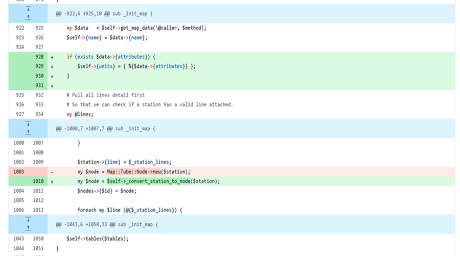
Now I have created a new subroutine _convert_station_to_node() as below, which would populate the new attribute attrs of Map::Tube::Node package.
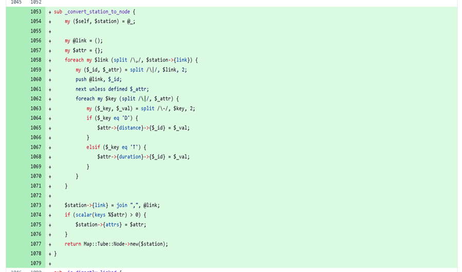
Now time to plug-in the new subroutine to the sub _init_map(), this is core subroutine which initialises the map data.
If you noticed, I am also populating the units attribute of the Map::Tube package.
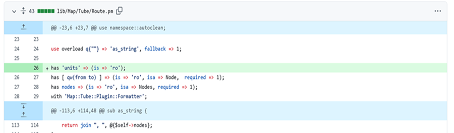
We need to make some space in the Map::Tube::Route package to capture the units detail. It is optional.
We have new attribute units as shown below:
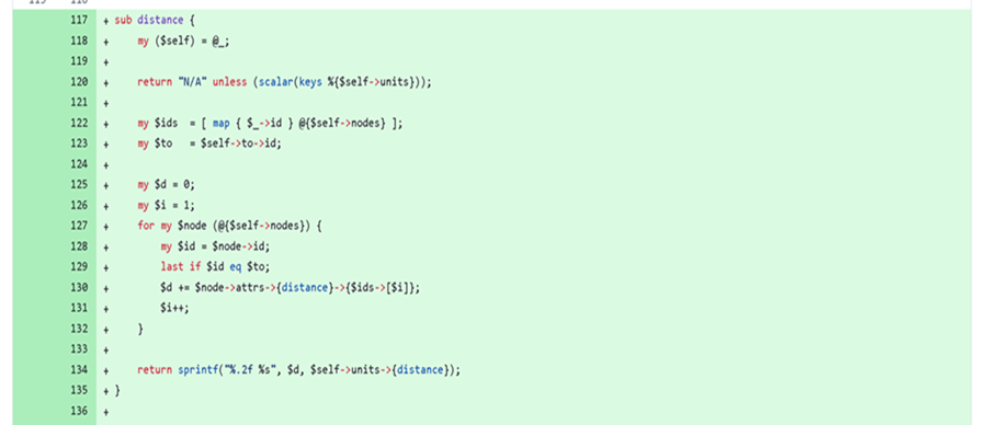
Finally we need subroutines to calculate the distance and durations of the final route.
Source: subroutine duration()

Source: subroutine distance()
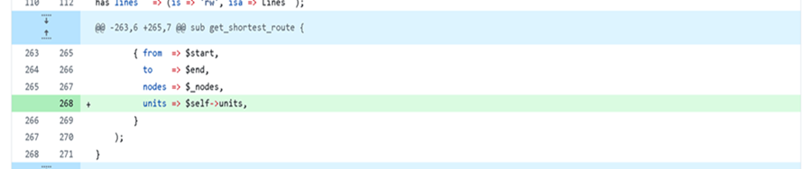
One final bit, we need to populate the newly added attribute units in the Map::Tube::Route package.
And the best place to do that when we calculate the shortest route in the sub get_shortest_route() in the Map::Tube package.
I think we are good to go now.
The core framework is ready to serve the new map data we have defined above.
Let’s create simple script to test the workflow: find-route.pl
package Sample;

use v5.38;
use Moo;
use File::Spec;

has xml => (
    is      => 'ro',
    default => sub { return File::Spec->catfile('sample.xml') });

with 'Map::Tube';

package main;

my $route = Sample->new->get_shortest_route($ARGV[0], $ARGV[1]);

print "Route: $route\n";
print "Distance: ", $route->distance, "\n";
print "Duration: ", $route->duration, "\n";
Testing time:
$ perl find-route.pl 'C' 'G'
Route: C (L1, L2), F (L1, L2), G (L1, L2)
Distance: 5.00 km
Duration: 48 min
$ perl find-route.pl 'E' 'H'
Route: E (L1), F (L1, L2), G (L1, L2), H (L1, L2)
Distance: 5.80 km
Duration: 51 min
As I mentioned above this change in the framework is currently saved in a separate repository, feel free to play with it.
In the meantime, I will continue to explore this further.
If you have any suggestion please feel free to share with me: mohammad.anwar@yahoo.com
Happy Hacking!!